 Cycle Maps
Cycling routes in Hanover
Cycle Maps lists cycling routes as tracks. 4 rides Hanover is known for, then 19 other tracks within 16 km of the centre of Hanover, Germany, longest first.
- 23 tracks
- 80.2 km (49.8 mi) the longest
- 284.6 km (176.8 mi) in all

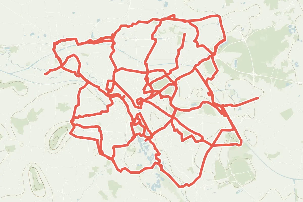
First come rides Hanover is known for: Julius-Trip-Ring, a loop of 24.1 km (15.0 mi); Grüner Ring - Basisring, a loop of 80.2 km (49.8 mi); Maschsee, a loop of 6.1 km (3.8 mi); and Hannover-City-Sightseeing Radtour, a loop of 24.7 km (15.4 mi). The longest ride or track here is Grüner Ring - Basisring, 80.2 km (49.8 mi). Veloroute 1 - City-Radring ends where it starts. Veloroute 1 - City-Radring runs through the centre itself. Of those of 5 km or more, the hilliest is Grüner Ring - Basisring, with about 320 m of climb over 80.2 km (49.8 mi), and the flattest Maschsee, with almost none. 2 long-distance routes pass through as well: Regionsring and Leine-Heide-Radweg.
How people ride in Germany: a typical ride in Germany was 8.3 km (5.2 mi), at 16.0 km/h (10 mph) while moving, from the rides of 602 Cycle Maps riders in 2014–2022.
How long
- 2 under 5 km (3 mi)
- 18 of 5 to 20 km (3 to 12 mi)
- 3 over 20 km (12 mi)
How hilly
- Flat 17
- Rolling 4
By each one’s climb per kilometre: flat under 5 m (26 ft a mile), hilly from 15 m (79 ft a mile). Most climbs are estimated.
Popular rides in Hanover
Chosen by Cycle Maps among the tracks mapped in OpenStreetMap: rides Hanover is known for.
- Julius-Trip-Ring Cycling track Flat 24.1 km (15.0 mi) Loop · About 70 m (230 ft) of climb · 1.3 km (0.8 mi) from the centre
- Grüner Ring - Basisring Cycling track Flat 80.2 km (49.8 mi) Loop · About 320 m (1,050 ft) of climb · 5.2 km (3.3 mi) from the centre OpenStreetMap: “Bicycle route around Hannover, which is marked by blue painted objects along the way”
- Maschsee Cycling track Flat 6.1 km (3.8 mi) Loop · Almost flat · 1.2 km (0.8 mi) from the centre
- Hannover-City-Sightseeing Radtour Cycling track Flat 24.7 km (15.4 mi) Loop · About 80 m (260 ft) of climb · 129 m (423 ft) from the centre OpenStreetMap: “Starting from the main train station, the 24-kilometer long tour leads to selected landmarks and complements the Red Thread”
On the map
Each line is a track; tap one for its name.
Other tracks around Hanover
- Ihme Cycling track Flat 10.8 km (6.7 mi) Ihmemündung to Devese · About 20 m (70 ft) of climb · 1.3 km (0.8 mi) from the centre
- Schiffgraben Cycling track Flat 10.4 km (6.5 mi) Emmichplatz to Altwarmbüchen · About 30 m (100 ft) of climb · 1.1 km (0.7 mi) from the centre
- Tiergarten Cycling track Flat 10.3 km (6.4 mi) Pferdeturm to Anderten · About 40 m (130 ft) of climb · 3.5 km (2.2 mi) from the centre
- Mecklenheide Cycling track Rolling 10.0 km (6.2 mi) Marienwerder to Godshorn · About 60 m (200 ft) of climb · 6.5 km (4.0 mi) from the centre
- Mittlere Leineaue Cycling track Flat 9.7 km (6.0 mi) Königsworther Platz to Seelze · About 30 m (100 ft) of climb · 1.6 km (1.0 mi) from the centre
- Seelhorst Cycling track Rolling 9.7 km (6.0 mi) Bischofshol to Mittellandkanal · About 80 m (260 ft) of climb · 3.6 km (2.3 mi) from the centre
- Mittellandkanal Cycling track Flat 9.4 km (5.8 mi) About 20 m (70 ft) of climb · 6.1 km (3.8 mi) from the centre
- Silbersee Cycling track Flat 8.9 km (5.5 mi) Emmichplatz to Neue Bult · About 20 m (70 ft) of climb · 1.0 km (0.6 mi) from the centre
- Wietze Cycling track Flat 8.6 km (5.3 mi) Wietzblick to Lahe · About 30 m (100 ft) of climb · 7.6 km (4.7 mi) from the centre
- Veloroute 3 Cycling track Flat 8.4 km (5.2 mi) Hannover to Bothfeld · About 20 m (70 ft) of climb · 886 m (2,907 ft) from the centre
- Mühlenberg Cycling track Flat 7.8 km (4.8 mi) About 20 m (70 ft) of climb · 4.7 km (2.9 mi) from the centre
- Herrenhäuser Gärten Cycling track Flat 7.3 km (4.5 mi) Königsworther Platz to Godshorn · About 20 m (70 ft) of climb · 1.3 km (0.8 mi) from the centre
- Veloroute 6 Cycling track Rolling 7.2 km (4.5 mi) Hannover to Kronsberg · About 40 m (130 ft) of climb · 384 m (1,260 ft) from the centre
- Eilenriede Cycling track Rolling 7.0 km (4.3 mi) Maschsee to Steuerndieb · About 50 m (160 ft) of climb · 3.0 km (1.8 mi) from the centre
- Veloroute 2 - Radschnellweg Hannover-Langenhagen Cycling track Flat 6.7 km (4.2 mi) Hannover City to Langenhagen · About 10 m (30 ft) of climb · 843 m (2,766 ft) from the centre
- Veloroute 9 Cycling track Flat 5.5 km (3.4 mi) Hannover City to Wettbergen · About 10 m (30 ft) of climb · 1.2 km (0.8 mi) from the centre
- Fösse Cycling track Flat 5.4 km (3.4 mi) About 20 m (70 ft) of climb · 2.7 km (1.7 mi) from the centre
- Südliche Leineaue Cycling track 4.7 km (2.9 mi) Ricklinger Kiesteichen to Wülfeler Leinemasch · Almost flat · 3.7 km (2.3 mi) from the centre
- Veloroute 1 - City-Radring Cycling track 1.8 km (1.1 mi) Loop · Almost flat · through the centre
Long-distance routes through Hanover
Lengths and climbs are for the whole route.
- Regionsring (RR) Regional, cycling 278.9 km (173.3 mi) · on OpenStreetMap Loop · about 11.1 km (6.9 mi) from the centre OpenStreetMap: “The Regionsring encircles the Hannover region, connecting its highlights along a route through scenic areas”
- Leine-Heide-Radweg (LHR) Regional, cycling 410.0 km (254.8 mi) · on OpenStreetMap Leinefelde to Hamburg · about 1.4 km (0.8 mi) from the centre OpenStreetMap: “The Leine-Heide Cycle Path connects the low mountain range landscape of the Leinebergland with the Lüneburg Heath and the city of Hamburg”
About this list
OpenStreetMap has 79 tracks in or near the square searched around Hanover; this page shows 4 popular rides, 19 tracks and 2 long-distance routes. Each name is listed once: 1 track with the name of a ride above is left out. The centre is taken as 52.3744° N, 9.7386° E, and the list was made on 1 November 2026. How the city lists are made.
Cities near Hanover
- Bremen Germany · 100 km (62 mi) away
- Hamburg Germany · 132 km (82 mi) away
- Münster Germany · 151 km (94 mi) away
- Lübeck Germany · 177 km (110 mi) away
- Erfurt Germany · 179 km (111 mi) away
Find tracks anywhere with the app
Cycle Maps is an Android app that finds cycling and mountain-bike tracks near any spot on the map.