 Cycle Maps
Cycling routes in Dresden
Cycle Maps lists cycling routes as tracks. 3 rides Dresden is known for, then 22 other tracks within 16 km of the centre of Dresden, Germany, longest first.
- 25 tracks
- 69.4 km (43.1 mi) the longest
- 878.1 km (545.6 mi) in all

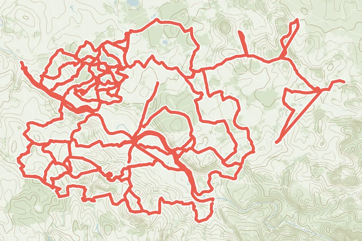
First come rides Dresden is known for: Elberadweg linkselbisch, Abschnitt N, 42.6 km (26.5 mi) from Meißen to Heidenau; Erlebnisregion Dresden Route 6, a loop of 54.7 km (34.0 mi); and Moritzburger Ring, a loop of 37.9 km (23.5 mi). The longest ride or track here is Kulturroute, 69.4 km (43.1 mi). 13 of them end where they start. Radroute Ost-West runs through the centre itself. Of those of 5 km or more, the hilliest is Erlebnisregion Dresden Route 5, with 1,000 m of climb over 57.6 km (35.8 mi), and the flattest Radroute Dresden Ost, with about 10 m. 2 long-distance routes pass through as well: EuroVelo 7 - Solrute and Mittelland-Route.
How people ride in Germany: a typical ride in Germany was 8.3 km (5.2 mi), at 16.0 km/h (10 mph) while moving, from the rides of 602 Cycle Maps riders in 2014–2022.
How long
- 1 under 5 km (3 mi)
- 6 of 5 to 20 km (3 to 12 mi)
- 18 over 20 km (12 mi)
How hilly
- Flat 3
- Rolling 19
- Hilly 2
By each one’s climb per kilometre: flat under 5 m (26 ft a mile), hilly from 15 m (79 ft a mile). Most climbs are estimated.
Popular rides in Dresden
Chosen by Cycle Maps among the tracks mapped in OpenStreetMap: rides Dresden is known for.
- Elberadweg linkselbisch, Abschnitt N (D10) Cycling track Flat 42.6 km (26.5 mi) Meißen to Heidenau · About 80 m (260 ft) of climb · 419 m (1,375 ft) from the centre
- Erlebnisregion Dresden Route 6 Cycling track Rolling 54.7 km (34.0 mi) Loop · 500 m (1,640 ft) of climb · through the centre
- Moritzburger Ring Cycling track Rolling 37.9 km (23.5 mi) Loop · About 290 m (950 ft) of climb · 8.3 km (5.1 mi) from the centre
On the map
Each line is a track; tap one for its name.
Other tracks around Dresden
- Kulturroute Cycling track Rolling 69.4 km (43.1 mi) About 810 m (2,660 ft) of climb · 15.0 km (9.3 mi) from the centre
- Erlebnisregion Dresden Route 3 Cycling track Rolling 63.2 km (39.2 mi) Loop · 400 m (1,312 ft) of climb · 703 m (2,306 ft) from the centre
- Erlebnisregion Dresden Route 2 Cycling track Rolling 60.2 km (37.4 mi) Loop · 700 m (2,297 ft) of climb · 12.0 km (7.5 mi) from the centre
- Erlebnisregion Dresden Route 5 Cycling track Hilly 57.6 km (35.8 mi) Loop · 1,000 m (3,281 ft) of climb · 6.2 km (3.9 mi) from the centre
- Erlebnisregion Dresden Route 7 Cycling track Rolling 55.1 km (34.2 mi) Loop · 700 m (2,297 ft) of climb · 8.1 km (5.0 mi) from the centre
- Erlebnisregion Dresden Route 4 Cycling track Rolling 54.1 km (33.6 mi) Loop · 550 m (1,804 ft) of climb · 4.1 km (2.5 mi) from the centre
- Zille-Radweg Cycling track Flat 54.1 km (33.6 mi) Loop · About 260 m (850 ft) of climb · 7.9 km (4.9 mi) from the centre
- Erlebnisregion Dresden Route 1 Cycling track Rolling 46.8 km (29.1 mi) Loop · 400 m (1,312 ft) of climb · 12.5 km (7.8 mi) from the centre
- Elbe-Moritzburg-Lößnitzgrund-Radweg Cycling track Rolling 36.3 km (22.6 mi) Loop · About 210 m (690 ft) of climb · 7.9 km (4.9 mi) from the centre
- Rund um Wilsdruff Cycling track Rolling 33.6 km (20.9 mi) Loop · About 290 m (950 ft) of climb · 10.6 km (6.6 mi) from the centre
- Saubachtal-Salzstraße-Radroute Cycling track Rolling 32.0 km (19.9 mi) Klipphausen to Radeburg · About 290 m (950 ft) of climb · 12.4 km (7.7 mi) from the centre
- Fischer-Route Cycling track Rolling 28.6 km (17.8 mi) Loop · About 180 m (590 ft) of climb · 10.0 km (6.2 mi) from the centre
- Weinberge-Tour Cycling track Rolling 28.0 km (17.4 mi) Loop · About 230 m (750 ft) of climb · 7.1 km (4.4 mi) from the centre
- Elbe-Nassau-Friedewald-Radrundtour Cycling track Rolling 24.5 km (15.2 mi) Loop · About 170 m (560 ft) of climb · 14.4 km (9.0 mi) from the centre
- Route M Cycling track Rolling 23.7 km (14.7 mi) Meißen to Moritzburg · About 170 m (560 ft) of climb · 13.2 km (8.2 mi) from the centre
- Kleinkuppenweg Cycling track Rolling 19.8 km (12.3 mi) Loop · About 110 m (360 ft) of climb · 12.3 km (7.6 mi) from the centre
- Radroute Nord-Süd Cycling track Rolling 18.7 km (11.6 mi) About 210 m (690 ft) of climb · 520 m (1,706 ft) from the centre
- Radroute Ost-West Cycling track Rolling 16.5 km (10.2 mi) About 90 m (300 ft) of climb · through the centre
- Radroute Dresden Ost Cycling track Flat 6.4 km (3.9 mi) Dresden Stadtzentrum (Straßburger Platz) to Dresden Tolkewitz (Schulcampus Tolkewitz) · About 10 m (30 ft) of climb · 1.3 km (0.8 mi) from the centre
- Südroute Cycling track Rolling 5.8 km (3.6 mi) About 50 m (160 ft) of climb · 4.1 km (2.5 mi) from the centre
- Radweg Weißig - Wachwitz Cycling track Hilly 5.2 km (3.2 mi) About 200 m (660 ft) of climb · 7.1 km (4.4 mi) from the centre
- Radweg Cunnersdorf - Niederpoyritz Cycling track 3.5 km (2.2 mi) About 150 m (490 ft) of climb · 8.1 km (5.0 mi) from the centre
Long-distance routes through Dresden
Lengths and climbs are for the whole route. A route made of other routes that states no length has none here: measured, it would count its variants too.
- EuroVelo 7 - Solrute (EV7) International, cycling · no length stated · on OpenStreetMap Nordkap to Valletta · about 2.3 km (1.4 mi) from the centre
- Mittelland-Route (D4) National, cycling 1,045.0 km (649.3 mi) · on OpenStreetMap Aachen to Zittau · about 446 m (1,463 ft) from the centre
About this list
OpenStreetMap has 54 tracks in or near the square searched around Dresden; this page shows 3 popular rides, 22 tracks and 2 long-distance routes. The centre is taken as 51.0504° N, 13.7373° E, and the list was made on 1 November 2026. How the city lists are made.
Cities near Dresden
- Leipzig Germany · 100 km (62 mi) away
- Prague Czechia · 119 km (74 mi) away
- Potsdam Germany · 156 km (97 mi) away
- Berlin Germany · 165 km (103 mi) away
- Erfurt Germany · 189 km (118 mi) away
Find tracks anywhere with the app
Cycle Maps is an Android app that finds cycling and mountain-bike tracks near any spot on the map.