 Cycle Maps
Cycling routes and mountain-bike trails in Salzburg
Cycle Maps lists cycling routes and mountain-bike trails as tracks. 3 rides Salzburg is known for, then 18 other tracks within 16 km of the centre of Salzburg, Austria, longest first.
- 21 tracks
- 101.2 km (62.9 mi) the longest
- 391.6 km (243.4 mi) in all

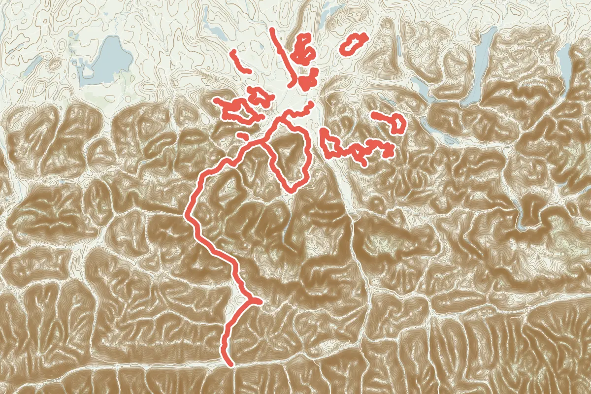
First come rides Salzburg is known for: Tauernradweg, Etappe Salzburg - Zell am See, 101.2 km (62.9 mi) from Salzburg to Zell am See; Rund um den Untersberg, a loop of 45.6 km (28.3 mi); and Wallersee-Runde, a loop of 18.1 km (11.2 mi). Of the 18 other tracks around the centre, 10 are for cycling and 8 for mountain bikes. The longest ride or track here is Tauernradweg, Etappe Salzburg - Zell am See, 101.2 km (62.9 mi). 10 of them end where they start. The nearest to the centre is Kleine Plain-Runde, 3.3 km (2.0 mi) from it. Of those of 5 km or more, the hilliest is Tauernradweg, Etappe Salzburg - Zell am See, with about 1,320 m of climb over 101.2 km (62.9 mi), and the flattest Familienradweg, with about 30 m. 5 long-distance routes pass through as well: EuroVelo 7 - Solrute, Alpe Adria Radweg, Mozart-Radweg mit Verbindungswege und Abstecher, Radweg D11: Ostsee <> Oberbayern and Salzkammergut BergeSeen eTrail.
How long
- 3 under 5 km (3 mi)
- 12 of 5 to 20 km (3 to 12 mi)
- 6 over 20 km (12 mi)
How hilly
- Flat 1
- Rolling 6
- Hilly 11
By each one’s climb per kilometre: flat under 5 m (26 ft a mile), hilly from 15 m (79 ft a mile). Most climbs are estimated.
Popular rides in Salzburg
Chosen by Cycle Maps among the tracks mapped in OpenStreetMap: rides Salzburg is known for.
- Tauernradweg, Etappe Salzburg - Zell am See Cycling track Rolling 101.2 km (62.9 mi) Salzburg to Zell am See · About 1,320 m (4,330 ft) of climb · 220 m (722 ft) from the centre
- Rund um den Untersberg Cycling track Rolling 45.6 km (28.3 mi) Loop · About 660 m (2,170 ft) of climb · 5.9 km (3.7 mi) from the centre
- Wallersee-Runde Cycling track Rolling 18.1 km (11.2 mi) Loop · 155 m (509 ft) of climb · 13.2 km (8.2 mi) from the centre
On the map
Each line is a track; tap one for its name.
Other tracks around Salzburg
- Steineralm Runde Mountain-bike track Hilly 29.4 km (18.3 mi) Loop · About 850 m (2,790 ft) of climb · 10.6 km (6.6 mi) from the centre
- TG26 Gaissau-Hintersee Mountain-bike track Hilly 21.2 km (13.1 mi) Gaissau to Hintersee · 746 m (2,448 ft) of climb · 14.7 km (9.1 mi) from the centre
- Loibersbacher Höhe Bike&Hike Mountain-bike track Hilly 20.8 km (12.9 mi) Faistenau to Loibersbacher Höhe · 800 m (2,625 ft) of climb · 14.0 km (8.7 mi) from the centre
- Höglrunde von Norden Mountain-bike track Hilly 20.1 km (12.5 mi) Loop · About 540 m (1,770 ft) of climb · 8.2 km (5.1 mi) from the centre
- Natur Erlebnis-Tour Tennengau Cycling track Rolling 19.9 km (12.3 mi) Loop · 265 m (869 ft) of climb · 6.4 km (4.0 mi) from the centre
- Antheringer "Maunzteufeltour" Cycling track Hilly 17.0 km (10.5 mi) Loop · About 290 m (950 ft) of climb · 9.6 km (5.9 mi) from the centre
- Familienradweg Cycling track Flat 15.4 km (9.6 mi) About 30 m (100 ft) of climb · 5.7 km (3.5 mi) from the centre
- TG25 Knoglberg loop Mountain-bike track Hilly 13.8 km (8.6 mi) Loop · 736 m (2,415 ft) of climb · 13.4 km (8.3 mi) from the centre
- Antheringer Berg- und Seentour Cycling track Hilly 12.0 km (7.4 mi) Loop · About 190 m (620 ft) of climb · 8.7 km (5.4 mi) from the centre
- TG24 Schlenken tour Mountain-bike track Hilly 10.3 km (6.4 mi) Adnet to Zillhütte · 911 m (2,989 ft) of climb · 12.5 km (7.8 mi) from the centre
- Stoißer Alm von Anger Mountain-bike track Hilly 9.3 km (5.8 mi) About 730 m (2,400 ft) of climb · 14.3 km (8.9 mi) from the centre
- Maria Plain - Rundweg Cycling track Hilly 8.5 km (5.3 mi) Loop · 195 m (640 ft) of climb · 4.1 km (2.5 mi) from the centre
- Fischach-Runde Cycling track Rolling 8.5 km (5.3 mi) Loop · About 100 m (330 ft) of climb · 5.1 km (3.2 mi) from the centre
- Petting - Weildorf Cycling track Rolling 7.3 km (4.5 mi) Petting to Weildorf · About 60 m (200 ft) of climb · 14.8 km (9.2 mi) from the centre
- Kleine Plain-Runde Cycling track Hilly 5.4 km (3.3 mi) Loop · 150 m (492 ft) of climb · 3.3 km (2.0 mi) from the centre
- Freilassinger Radrundweg Cycling track 3.3 km (2.0 mi) About 10 m (30 ft) of climb · 5.7 km (3.5 mi) from the centre
- Kleine Fischach-Runde Cycling track 2.4 km (1.5 mi) Loop · 20 m (66 ft) of climb · 5.1 km (3.2 mi) from the centre
- Zwieselalm Mountain-bike track 2.3 km (1.5 mi) About 130 m (430 ft) of climb · 15.6 km (9.7 mi) from the centre
Long-distance routes through Salzburg
Lengths and climbs are for the whole route. A route made of other routes that states no length has none here: measured, it would count its variants too.
- EuroVelo 7 - Solrute (EV7) International, cycling · no length stated · on OpenStreetMap Nordkap to Valletta · about 2.0 km (1.2 mi) from the centre
- Alpe Adria Radweg (CAAR) International, cycling 423.0 km (262.8 mi) · its page in German Salzburg, AT to Grado, IT · about 267 m (876 ft) from the centre
- Mozart-Radweg mit Verbindungswege und Abstecher (MOZ) National, cycling 410.0 km (254.8 mi) · on OpenStreetMap Loop · about 410 m (1,345 ft) from the centre
- Radweg D11: Ostsee <> Oberbayern National, cycling 1,697.0 km (1,054.5 mi) · on OpenStreetMap About 7.6 km (4.7 mi) from the centre
- Salzkammergut BergeSeen eTrail (S 800) National, mountain-bike 630.0 km (391.5 mi) · on OpenStreetMap Loop · about 9.6 km (6.0 mi) from the centre
About this list
OpenStreetMap has 54 tracks in or near the square searched around Salzburg; this page shows 3 popular rides, 18 tracks and 5 long-distance routes. The centre is taken as 47.7981° N, 13.0465° E, and the list was made on 1 November 2026. How the city lists are made.
Cities near Salzburg
- Munich Germany · 116 km (72 mi) away
- Innsbruck Austria · 137 km (85 mi) away
- Regensburg Germany · 153 km (95 mi) away
- Graz Austria · 197 km (123 mi) away
- Vienna Austria · 252 km (156 mi) away
Find tracks anywhere with the app
Cycle Maps is an Android app that finds cycling and mountain-bike tracks near any spot on the map.