 Cycle Maps
Cycling routes and mountain-bike trails in Dublin
Cycle Maps lists cycling routes and mountain-bike trails as tracks. 3 rides Dublin is known for, then 12 other tracks within 16 km of the centre of Dublin, Ireland, longest first.
- 15 tracks
- 148.4 km (92.2 mi) the longest
- 287.3 km (178.5 mi) in all

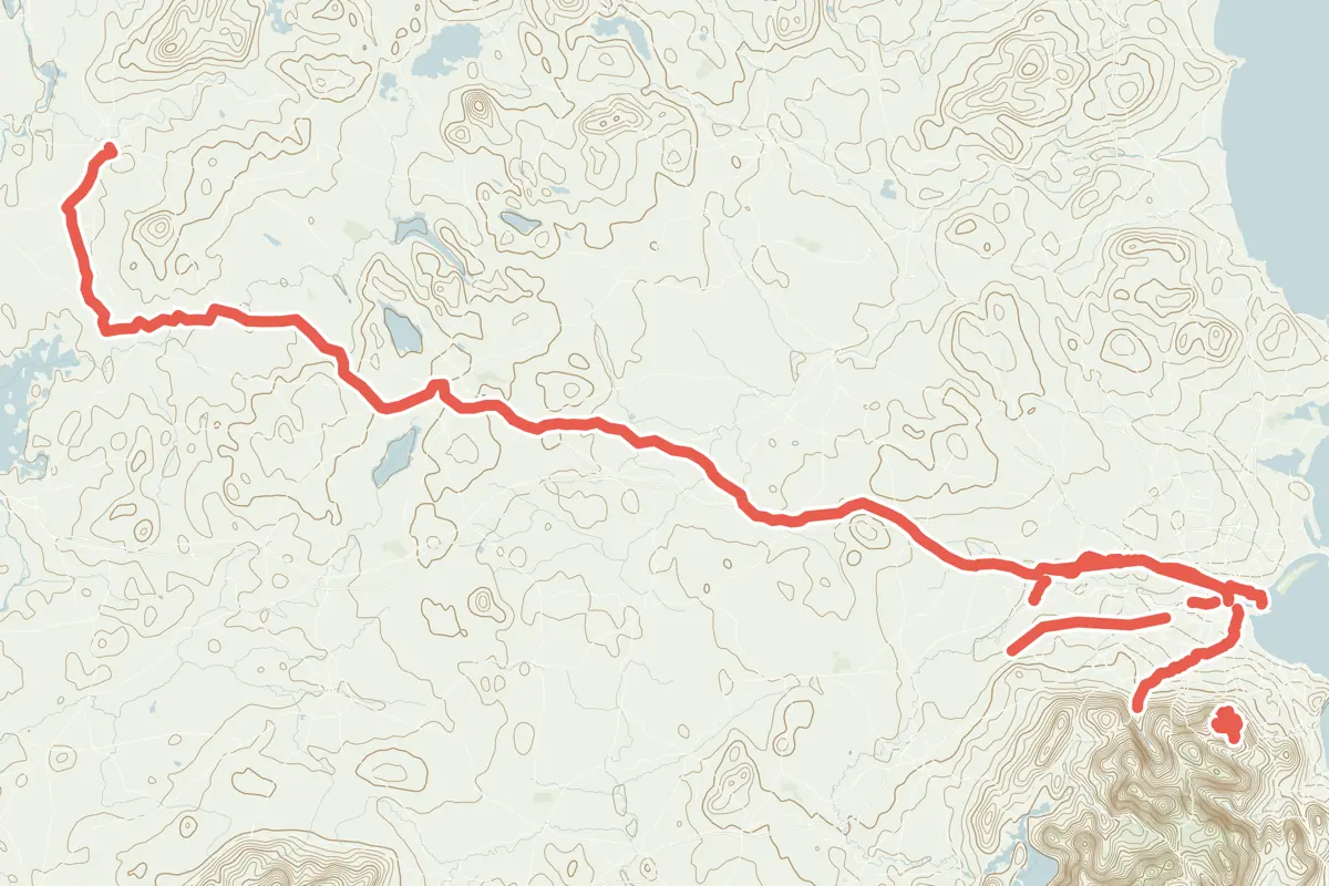
First come rides Dublin is known for: Royal Canal Greenway into Dublin, 24.8 km (15.4 mi); Grand Canal Greenway, 15.0 km (9.3 mi); and Dodder Greenway, 16.2 km (10.1 mi). Of the 12 other tracks around the centre, 11 are for cycling and one for mountain bikes. The longest ride or track here is Royal Canal Greenway, 148.4 km (92.2 mi). Ticknock MTB Trail ends where it starts. The nearest to the centre is Liffey Cycle Route, 260 m (853 ft) from it. Of those of 5 km or more, the hilliest is Ticknock MTB Trail, with 201 m of climb over 16.3 km (10.1 mi), and the flattest East Coast Trail, with about 20 m. One long-distance route passes through as well: EuroVelo 2 - Capitals Route - part Irish Sea.
How long
- 6 under 5 km (3 mi)
- 7 of 5 to 20 km (3 to 12 mi)
- 2 over 20 km (12 mi)
How hilly
- Flat 5
- Rolling 4
By each one’s climb per kilometre: flat under 5 m (26 ft a mile), hilly from 15 m (79 ft a mile). Most climbs are estimated.
Popular rides in Dublin
Chosen by Cycle Maps among the tracks mapped in OpenStreetMap: rides Dublin is known for.
- Royal Canal Greenway into Dublin Cycling track Flat 24.8 km (15.4 mi) The longest stretch of the route “EuroVelo 2 - part Ireland” within 16 km of the centre · About 70 m (230 ft) of climb · 1.2 km (0.8 mi) from the centre
- Grand Canal Greenway Cycling track Flat 15.0 km (9.3 mi) About 40 m (130 ft) of climb · 4.9 km (3.0 mi) from the centre
- Dodder Greenway Cycling track Rolling 16.2 km (10.1 mi) About 110 m (360 ft) of climb · 2.3 km (1.4 mi) from the centre
On the map
Each line is a track; tap one for its name.
Other tracks around Dublin
- Royal Canal Greenway Cycling track Flat 148.4 km (92.2 mi) Longford to Spencer Dock · About 150 m (490 ft) of climb · 1.2 km (0.8 mi) from the centre
- East Coast Trail Cycling track Flat 19.8 km (12.3 mi) About 20 m (70 ft) of climb · 2.2 km (1.4 mi) from the centre
- Ticknock MTB Trail Mountain-bike track Rolling 16.3 km (10.1 mi) Loop · 201 m (659 ft) of climb · 10.4 km (6.5 mi) from the centre
- Mountains to Metals Cycling track Rolling 11.6 km (7.2 mi) About 80 m (260 ft) of climb · 7.4 km (4.6 mi) from the centre
- Sea to Mountains Cycling track Rolling 10.6 km (6.6 mi) About 130 m (430 ft) of climb · 6.8 km (4.2 mi) from the centre
- Park to Park Cycling track Flat 10.3 km (6.4 mi) About 30 m (100 ft) of climb · 7.6 km (4.7 mi) from the centre
- Tolka Greenway Cycling track 3.3 km (2.1 mi) About 10 m (30 ft) of climb · 3.5 km (2.2 mi) from the centre
- Santry River Greenway Cycling track 2.8 km (1.8 mi) Almost flat · 5.7 km (3.6 mi) from the centre
- Arthur's Way Cycling track 2.3 km (1.4 mi) About 10 m (30 ft) of climb · 15.7 km (9.7 mi) from the centre
- Liffey Cycle Route Cycling track 2.2 km (1.4 mi) Almost flat · 260 m (853 ft) from the centre
- Dublin Port Greenway Cycling track 2.1 km (1.3 mi) Almost flat · 2.9 km (1.8 mi) from the centre
- Dalkey Blue Way Cycling track 1.5 km (0.9 mi) Almost flat · 10.6 km (6.6 mi) from the centre
Long-distance routes through Dublin
Lengths and climbs are for the whole route. A route made of other routes that states no length has none here: measured, it would count its variants too.
About this list
OpenStreetMap has 26 tracks in or near the square searched around Dublin; this page shows 3 popular rides, 12 tracks and 1 long-distance route. 2 tracks shorter than 1 km are left out. Each name is listed once: 4 tracks with the name of a ride above are left out. The centre is taken as 53.3498° N, 6.2603° W, and the list was made on 24 October 2026. How the city lists are made.
Cities near Dublin
- Bristol United Kingdom · 326 km (203 mi) away
- Edinburgh United Kingdom · 350 km (218 mi) away
- London United Kingdom · 463 km (288 mi) away
Find tracks anywhere with the app
Cycle Maps is an Android app that finds cycling and mountain-bike tracks near any spot on the map.